Geolocated MapView Coming to AkitaBox
Nov. 7, 2025, Madison, WI: For too long, facility conditions assessments and facilities management required toggling between GIS systems, digital plans, and CMMS data. We’re ending that complexity.
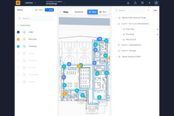
Coming soon … geolocated data in AkitaBox. This release brings unprecedented clarity and precision, allowing you to instantly move from a portfolio overview down to a specific asset’s location:
- Comprehensive Portfolio Map: Get a complete, at-a-glance overview of your entire asset portfolio on a single interactive map.
- Precision Geolocation: Pinpoint every asset with real-world accuracy. Place items using precise latitude/longitude coordinates to ensure your map reflects reality.
- Custom Asset Visualization: Clearly distinguish your assets. Represent different locations, buildings, or equipment with customizable map pins, icons, or geographic shapes (polygons).
- Dynamic Plan Overlays: Bring your site plans to life. Overlay detailed blueprints, schematics, or floor plans directly onto their real-world map locations.
- Advanced Alignment Toolkit: Perfectly align your plans every time. Use powerful tools to easily scale, rotate, crop, and position your overlays for a precise fit.
Be the First to Know
About AkitaBox
AkitaBox delivers an unrivaled data-driven software to assess and optimize the operation and condition of facilities, from the boiler room to the boardroom. Our cloud-based software provides real-time facilities data in a visual and easy-to-use, customizable format – helping teams simplify their operations, reduce risk, and solve even the most complex facility challenges. The AkitaBox suite of software solutions includes Facility Condition Assessment, Capture, Capital Management, CMMS, and Inspections. Visit akitabox.com.

AMFP Welcomes AkitaBox as National Platinum Partner for 2026
Coming Soon: AkitaBox Map Layers